TECH SHOWCASE

Project Discovery Facility


The project discovery solution is the answer for the posting of assets where these can be found easily and, where spatial context can de perceived. Instead of using a list or force the users to setup their own sites to publish their models, minex3D.com has prepared this geographic environment where people not directly related to the owner of the model can access these and discover what’s available on any location. This application uses a combination of the openlayers platform and public data sources with the minex3D database implementation leveraging on web-spatial data objects to bring otherwise difficult to find models to the public.


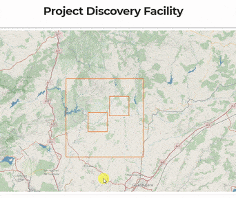
To use the interface, just explore the global interactive map by dragging & zooming in/out, the projects are highlighted on the terrain background. As you hover above any of the AOIs (polygons), a tooltip is loaded to give a broad info of what the selected project is about, and by clicking the selected item, a separate window executing the minex3D Application will fetch the model from DB. Visibility of individual projects depends on your own status, if you are visiting www.minex3D.com you only will see projects that have been published to the public, if you login to the user area (need to be subscribed) you will be able to see your private Areas Of Interest.

About The Following Demo Models

The following models demonstrate the platform's possible aplications and/or uses, ranging from the review of existing or projected infrastructure in a 3D context, through specific aplications as drillhole result presentation for mining exploration targets on various symbolized 3D representations of subsurface traces (eg. DH geophysics, DH lithology, DH rock quality, etc.) to visualization of fully integrated sets, acomodating surface infrastructure, lithology, environmental, land properties, tenement, reserves, imagery, 3D linear sets, 3D point data, up to 3D grids with complex symbolizations, and capacity for detailed exploration of attached databases. As demonstration sets these models are built from a combination of real and non-real data, whenever a model includes non-real data it is mentioned.

Simple Drill Hole View

Present drill results in a lite & compelling way, on the web, 3D with no installations

Simple demonstration 3D model with DEM, location of drillhole sites with labels, and drillhole traces with selectable symbolized intervals (color and cylinder diameter symbolization on content of an element per interval) with data base attached for detailed review. Useful for presenting of drillhole results. (random drilhole data)

Exploration Project Analysis

To review the full project data with the team, do the needed analysis anywhere

Compound model with real DEM and an overlay of geological features; each layer offers data on click, x & y coordinates in Lat-Lon plus elevation in meters (LL WGS84 standard) for DEM, lithology descriptions, geologic age, for polygon layer, drillhole traces with symbolization and data, and 3D grid with transparency & symbolization based on data. (data used to generate drillhole set and grid are non-real)

A Regional Context For a Proposal

Know the terrain from the start, for project proposals

Real DEM and overlay of geologic features, DEM uses satellite radar data for elevation and a shaded relief as imagery to enhase the depth perseption, with river & road features as part of the imagery, overlain by a translucent geology map, and centered the location for a planned water treatment plant, in the form of a point-box labeled object.